**** Canada Post is on strike again. Don't worry, WE USE OTHER COURIERS, so no delays!. ****

Premium Map: The Essential Geography of the Sea To Sky
  • Load image into Gallery viewer, Premium Map: The Essential Geography of the Sea To Sky
  • Load image into Gallery viewer, Premium Map: The Essential Geography of the Sea To Sky
  • Load image into Gallery viewer, Premium Map: The Essential Geography of the Sea To Sky
  • Load image into Gallery viewer, Premium Map: The Essential Geography of the Sea To Sky
  • Load image into Gallery viewer, Premium Map: The Essential Geography of the Sea To Sky
  • Load image into Gallery viewer, Premium Map: The Essential Geography of the Sea To Sky
⚠️ Canada Post Strike: All premium and poster maps are shipped using alternate shipping methods. Unfortunately, we cannot ship our folded maps at cost-effective rates so they will be available again once the strike is over.

Premium Map: The Essential Geography of the Sea To Sky

Regular price
$100.00
Sale price
$100.00
Regular price
Sold out
Unit price
per 
⚠️ U.S. Customers: Due to tariffs introduced under the Trump administration, U.S. customs may charge an additional 25–35% import duty on Canadian goods. These duties are calculated and collected at checkout (and paid to U.S. customs) to ensure smooth delivery with no surprise fees.

PREMIUM MAP DESCRIPTION:

A beautiful AWARD-WINNING reference map for your wall! 

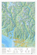
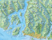
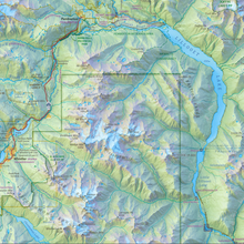
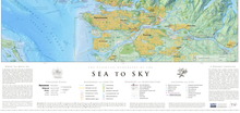
This beautiful reference map, awarded "Best of Show" in the prestigious CaGIS Map Design Competition (2024), represents the geographic essence of the Sea To Sky area and captures the journey from the coastal waters of Howe Sound to the mountain ranges of Whistler. The Sea to Sky area is within the traditional territories of the Squamish, Musqueam and Lil’wat First Nations – since time immemorial.

Created from over 75 different layers of information, this map is a pleasure to pore over with details and place names you've never seen before. 

PREMIUM MAP FEATURES:

  • Printed on premium 260 gsm (thick, heavy stock), low luster photographic paper.
  • High-quality, detailed print using commercial inkjet technology.
  • Suitable for framing / hanging on your walls. 
  • Map is shipped rolled in a tube - this is not a folded map.
  • Shipping is NOT included.